How’s the Weather…
Last week, I attended a meeting where Eric Snodgrass spoke. If you are unfamiliar, Eric manages ag-wx.com and a daily YouTube channel. I use his website and watch a lot of his videos to hear trends that are happening in weather and what these trends might lead to. Yes, that is a recommendation from me for you to check him out if you haven’t already. As a result of my trust in him, I wanted to share his insights from the meeting in this week’s Earfull.
El Niño has become one of the biggest weather headlines this year. But, the headline itself is not really the main thing that matters for us. What matters more is how the summer pattern actually sets up and whether it keeps giving us chances for rain as we move deeper into June and July.
There has been plenty of dramatic language around El Niño already, and that will probably continue. But from a practical standpoint, growers are usually better served by watching the pieces of the pattern that have a better chance of affecting their acres directly. This is where the conversation gets more useful, especially as we head toward the heart of summer.
For our area, there are three things worth watching a little closer right now. The first is moisture in the Mid-South, especially down around the Memphis area. The second is where the Bermuda High wants to set up. The third is the broader upstream pattern, including what is happening around the Gulf of Alaska.
Those three areas are not as flashy as a national weather headline, but they can tell us a lot about how the pattern may behave from here. If they line up in a workable direction, the central U.S. has a better shot at staying in a more functional rhythm. If they do not, it gets easier for heat to take control and for rainfall chances to become more scattered.
Area one: Memphis area moisture
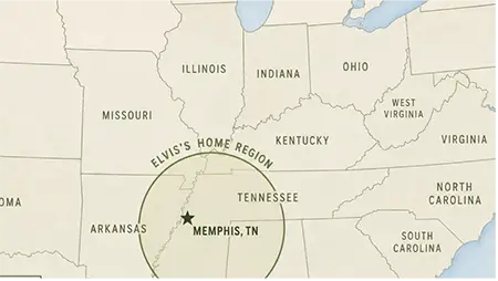
The first thing to watch is moisture in the Mid-South, especially in that corridor around west Tennessee and eastern Arkansas
That area may seem a little removed from our backyard, but it can still be an important signal for how the broader central U.S. pattern behaves.
When there is moisture in that region, it brings potential for better rainfall opportunities to keep moving through the system. It does not guarantee a favorable stretch. However, it usually gives the atmosphere a little more room to stay active rather than shutting down completely.
When that region turns dry, the pattern can get tough in a hurry. That is when the risk grows for more stubborn heat, fewer meaningful rain chances, and a season where missed rains start to matter more. In years when the margin is narrow, that is a signal worth paying attention to.
This is one reason why July weather is usually more about pattern support than any single storm. It is not always about whether a rain event shows up once. It is about whether the setup keeps creating enough chances to keep the crop in a workable position.
Area two: Bermuda High
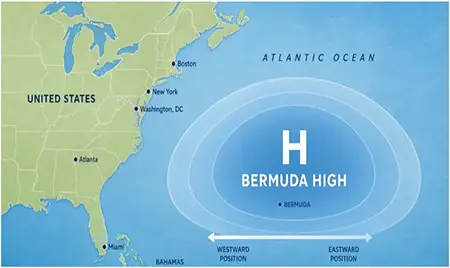
The second piece to watch is the Bermuda High. It does not always come up in everyday farm conversation, but it is one of the major summer features for the eastern half of the country.
If the Bermuda High pushes farther west, it can favor more heat and a less active setup across the East and Southeast. That kind of pattern can create more resistance and make it harder for the middle of the country to keep a healthy weather rhythm going.
If it stays farther east, there is usually a little more breathing room in the pattern. This tends to allow fronts and systems to move more naturally, which can help keep the central Corn Belt from turning stagnant too early.
That does not mean the Bermuda High decides the whole season by itself. But it is a feature that can quietly tilt the odds one direction or the other, and it is worth watching as we move into the hotter part of the calendar.
Area three: Upstream pattern
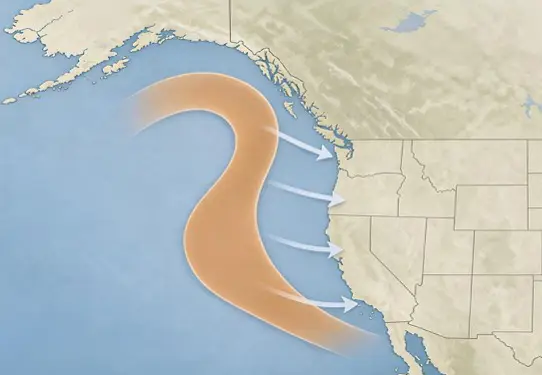
The third area to keep an eye on is the upstream pattern, especially around the Gulf of Alaska. It is not the kind of region most people talk about first when discussing Midwest weather, but it helps shape the broader North American flow.
If the setup in that part of the pattern favors stronger ridging, that can eventually work its way downstream and increase the risk of hotter and less forgiving conditions. “Ridging” is an area of relatively highly atmospheric pressure that has been extended from an elongated area. If the flow stays more progressive, it can help keep the overall pattern more active and gives us a better chance at repeated opportunities for rain.
This is the part that matters most. By the time we feel a weather pattern in July, some of its fingerprints may have already been set well upstream. Paying attention to those early clues can sometimes tell us more than a headline ever will.
So, yes, El Niño will keep getting the attention, and that is understandable. But for practical purposes, the better focus is probably simpler: watch moisture around the Memphis area, watch where the Bermuda High sets up, and watch the upstream pattern around the Gulf of Alaska.
Those three clues may end up telling us more about how summer behaves than any dramatic weather headline. They are not guarantees, and they do not decide the season on their own, but they are good places to keep watching as the summer pattern starts to take shape.
You can dig into much more on ag-wx.com as Eric’s site is a wealth of insights and information to stay on top of the number one conversation piece in the ag circles… how’s the weather.
References
- Eric Snodgrass, High Impact Meteorology, Bayer Seed Partner Meeting. www.ag-wx.com
- NOAA Climate Prediction Center said El Niño was likely to emerge soon in May-July 2026 and continue through winter 2026-27.
https://www.cpc.ncep.noaa.gov/products/analysis_monitoring/enso_advisory/ensodisc.shtml - The Bermuda High is a key summer weather feature for the eastern United States and its position can strongly affect heat, humidity, and storm tracks. https://site.extension.uga.edu/climate/2014/06/what-is-the-bermuda-high/